09 Aug 2023 | Cristián Moreno Pakarati
Taken Rapanui Heritage
In 2020, amidst the COVID pandemic, the tourism industry came to a complete halt, leaving Rapa Nui (also known as Easter Island) almost entirely isolated from the rest of the world. However, despite these challenges, the internet facilitated a project known as Taken Rapanui Heritage. This small-scale initiative resulted from a collaboration between two island organizations: ours, the Rapanui Pioneers Society, located in Hanga Roa, Rapa Nui, and The Earth Museum, based in the Isle of Wight, UK. Through a series of email exchanges and online meetings, a well-defined idea began to take shape: The project would be dedicated to mapping Rapanui heritage scattered throughout the world due to historical forces. This mapping would be done in three different and experimental ways.
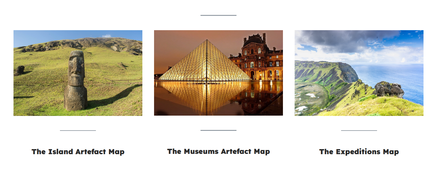
The broader idea behind the project — mapping Rapanui objects abroad — was not entirely new, as it had previously been applied to the relocation of both moai and rongorongo objects. Additionally, there is the Terevaka Archaeological Outreach, led by archaeologist Britton Shepardson, which features maps displaying numerous Rapanui objects housed in American museums. However, our concept differed in several significant ways: Firstly, we aimed to create an "Island Artefact Map," pinpointing specific locations within Rapa Nui where objects had been originally discovered before being taken away. Secondly, our "Museums Artefact Map" would showcase institutions worldwide that possessed items obtained from Rapa Nui. Finally, we envisioned an "Expeditions Map" illustrating the historical navigation routes to the island that facilitated the movement of these objects to antique stores, museums, and private collections.
The Island Artefact Map proved to be the first and, in particular, a challenging aspect for me as a researcher due to the limited availability of information. For many objects, the relevant archaeological collections only provided "Easter Island" as their provenance detail — without specifying the region, area, or site of their discovery. Recognizing that expedition or excavation reports were more likely to contain this specific information than the museum's online data, I delved into a lot of detective work. I meticulously studied the published works and field notes of expeditions known to have taken objects away from Rapa Nui until, through considerable effort, we managed to obtain precise provenance details for approximately 40 objects. Each of these objects is accompanied by a photograph of the site, the artefact itself, and a concise narrative about its origin and historical significance.
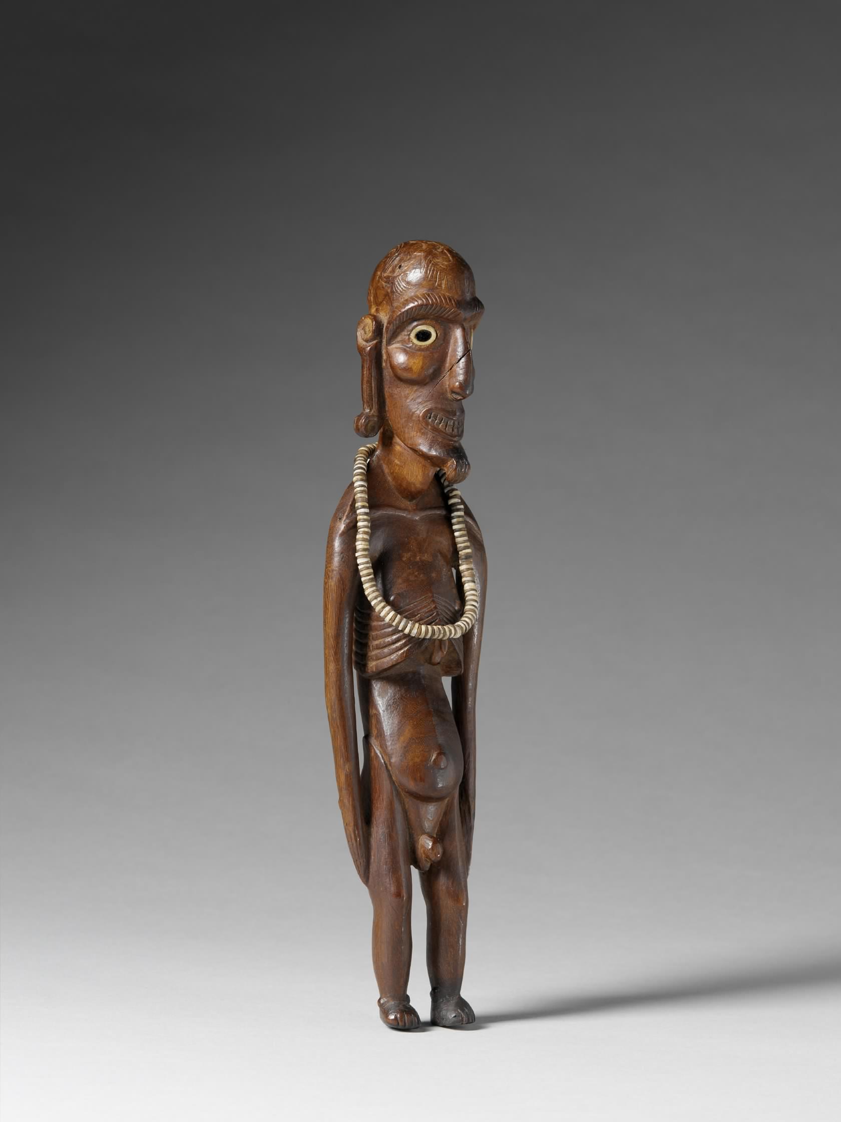 An example of the object types presented in Taken Rapanui Heritage: A 19th century moai kavakava taken from Rapa Nui on an unknown date (circa 1868-1877). Object 71.1887.31.67.1-4 of the Musée du Quai Branly, acquired from the Roland Bonaparte collection in 1887.
The Museums Artefact Map presented the opposite challenge; it entailed an overwhelming abundance of information. American and European museums have developed highly comprehensive online databases, housing thousands of items from Rapa Nui. Given our time and budget constraints, we made the decision to create a representative map rather than attempting to cover every single item, which would have taken months or even years. Our primary criteria were to include as many different types of objects as possible and represent various countries and continents.
As a result, we successfully traced the history, including the origin, extraction, and current location, of several dozen objects across North and South America, Europe, and Oceania. Similar to the first map, we provided photographs of the museums and the objects themselves, along with a concise history and description of each item.
Creating the Expeditions Map posed the most significant challenge for the maps team. To tackle this, I had already compiled an updated list of ships that visited Rapa Nui from 1722 to 1900, building upon the earlier work primarily done by Grant McCall and Rhys Richards. This updated list is accessible as a downloadable spreadsheet, facilitating the mapping of the departure ports for all these expeditions that journeyed past Rapa Nui.
Given the vast number of expeditions during that period, we carefully selected representative ones to be featured on the map, accompanied by brief descriptions and the stories of their voyages. Whenever possible, we included paintings or photographs depicting the ships or the ports they sailed from.
Undoubtedly, this has been an immensely enjoyable experience for me as a devoted researcher of Rapanui history. It is worth noting that both the second and third maps are subject to future updates and additional information as part of a potential second phase of the "Taken Rapanui Heritage" project. Currently, all three maps are accessible online, and the entire material is made available under a Creative Commons license, allowing for free usage.
The contributions of this project hold great value for individuals with an interest in colonial history, empires, museums, museology, Pacific history, and arts. The collaborative efforts for this endeavor were spearheaded by Janet Owen and Roxanne Baxter, representing The Earth Museum, alongside Natalia Pakomio Sobarzo and myself, representing the Rapanui Pioneers Society.